EAST TENNESSEE GEOLOGICAL SOCIETY
ETGS/AIPG Newsletter
May 2000
EAST TENNESSEE GEOLOGICAL
SOCIETY
and
TENNESSEE SECTION of the
AMERICAN INSTITUTE OF PROFESSIONAL GEOLOGISTS
In this issue...
ETGS/AIPG May Meeting
April Presentation Summary
Field Trip Planned for June
ETGS Postcard Campaign: Recruiting East
Tennessee PGs
Newsletter Named News Klippe
ETGS Educational Program
Earth Science Week
Online Topographic Maps
AIPG Scholarships
Contact Information
Monday, May 1, 2000
6:00 pm - 7:30 pm
Ryan's Family Steak House
9645 Kingston Pike
Knoxville, Tennessee
May Presentation
Stewardship After Cleanup
on the Oak Ridge Reservation
By
John Kubarewicz
Bechtel Jacobs Company/RSI
3jn@ornl.gov
Abstract
Nationwide, more than 100 DOE sites are expected to require post-remediation, long-term stewardship (LTS). The U.S. Department of Energy (DOE) has established the Office of Long-term Stewardship to address such issues as monitoring and management of residual contaminants; containment inspection, operation and maintenance, and replacement; maintenance of institutional controls; and record keeping. This presentation will provide an overview of LTS as it applies to Oak Ridge Operations (ORO), including the role of existing geologic data in the process. Stewardship activities, remediation end states, assumptions, and projected costs will be discussed.
by Carla Sparks
ETGS would like to thank Steven Jones with the Environment, Safety, Health, and Quality Organization, Lockheed Martin Energy Systems for his informative presentation during the April meeting. Steven presented information about Microbiologically Induced Corrosion (MIC) in stainless steel monitoring wells.
Under the right environmental conditions, it is possible for bacteria to thrive on the well casing and screen in a monitoring well. These organisms may corrode stainless steel, releasing the component metals. At the U.S. Department of Energy Y-12 Plant, an investigation is underway into possible links between such microbiological activity and nickel and chromium in monitoring wells.
A full abstract of Mr. Jones' presentation can be found in the April Newsletter.
by Carla Sparks
ETGS and AIPG announce plans for a late-spring field trip--a stratigraphic bicycle tour down the Virginia Creeper Trail. It will be an almost-all-downhill ride from White Top to Damascus. A shuttle service will be used to transport the group to a high point (near Whitetop Station), and we will ride downhill toward Damascus. The Virginia Creeper starts in Abingdon and ends just east of Whitetop Station for a total length of 33.4 miles. It began as a Native American footpath and became part of the Virginia-Carolina Railroad system in 1907. Now it serves as a multi-use recreation trail.
The trip will be held June 3, 2000. Additional information and registration requirements will be posted the Field Trip page. Please continue to check that site for details.
For more information on the Virginia Creeper Trail, check out the following web sites.
http://www.cccyclery.com/vacrep.htm
http://www.his.com/~jmenzies/urbanatb/rtrails/creeper/creeper.htm
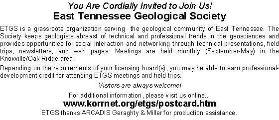
ETGS
POSTCARD CAMPAIGN
Recruiting East Tennessee Professional Geologists
by J. Brad Stephenson & Jim Morgan
As we discussed during the April meeting, a database has been prepared listing Professional Geologists (PGs) registered with the State of Tennessee. After removing ETGS members and PGs living outside East Tennessee, the list includes 369 potential new members.
Because the State does not maintain e-mail addresses in its records, it was decided that a postcard mailing would be the most cost-effective way to reach these folks. Jim Morgan and ARCADIS Geraghty & Miller (http://www.gmgw.com) provided tremendous support by formatting and printing the postcards. Seaira and Brad Stephenson handled the labels and stamps, and the postcards were mailed on Thursday, April 20.
Each postcard includes a brief description of the society and invites the recipient to our next meeting. (See below.) Because space is limited on the cards, they direct the recipients to a special page on the ETGS web site for more information.
The total investment by ETGS for postcards and stamps was less than $100. We will recover this outlay if only 7 people (1.9% of the recipients) join the organization for one year. More significantly, ETGS will benefit from the background and experience of each new member.
Please help with this recruitment effort. You are always encouraged to invite a friend or coworker to our meetings.
by Carla Sparks
After accepting nominations for naming the newsletter (formerly known as The ETGS Newsletter), ETGS members cast their votes for their title during the April meeting. As a result of that poll, our newsletter is now officially known as the News Klippe. Thanks and congratulations to Dr. Don Byerly for the name submission. He receives a complimentary membership for 2001. Thanks to everyone who submitted nominations.
by J.J. Hollars
Have you ever been asked to do a short geology presentation at you local elementary school? for the Scouts? a church group? Odds are that many of us have been asked to give just such a presentation only to beg out by saying that we had no materials prepared. NO MORE EXCUSES! Obviously, as professional geologists we all benefit by furthering the general knowledge of the earth sciences in our community. Therefore, ETGS would like to help its members prepare for and participate in those brief yet beneficial presentations by organizing presentation materials, samples etc. for use by all members.
I expect that many of our members have already developed the materials for their own presentations. Consequently, we would like to maintain a clearing house of materials that you and other members can contribute to so that you and other members could later borrow from for the their own presentations. This "program" if we dare call it that, is expected to grow through the years as we collect more and better educational materials. In the meantime, I would like to volunteer to manage our collection and remain as a "point man" when someone needs materials.
Do you have some materials or samples you or your office would like to contribute? It is certainly a worthy cause, and if you act quickly you can be the first to support what we hope will be a significant out growth of our organization. Give it a thought. I bet you have some materials that could really benefit others.
In the months to come we hope to coordinate with the Tennessee Earth Science Teachers (TEST) organization to see if we can develop a mutually beneficial relationship. More information about TEST can be found at http://www.utm.edu/departments/artsci/ggp/test/officer.html. Additional information about earth science education efforts may be found at http://www.earthsciweek.org.
by Chris Maner
Earth Science Week, the second full week in October, is an annual celebration of the contribution geoscience makes to society. The resolution to establish Earth Science Week was initiated by the Association of American State Geologists and was read into the Congressional Record in July 1998 by Senator Ron Wyden of Oregon. President Clinton followed this proclamation in October with a message encouraging all Americans to participate in Earth Science Week activities. The promotion of Earth Science Week is one of the 50th anniversary initiatives of the American Geological Institute (http://www.agiweb.org), of which AIPG is a member.
Earth Science Week web site:
http://www.earthsciweek.org
Other sites that are participating in Earth
Science Week:
http://www.usgs.gov/
http://www.azminfun.com/html/esw99/overview.html
http://www.geosociety.org/educate/earthbooks.htm
http://www.hgs.org/esw.htm
http://www.dnr.state.co.us/geosurvey
by J. Brad Stephenson
As frequent users of topographic maps, geologists should take note of a new web-based service. Maps a la Carte, Inc., a United States Geological Survey (USGS) Digital Cartographic Business Partner, launched TopoZone (www.topozone.com) late last year. This service provides free access to electronic (scanned) versions of the topographic maps we depend on in so many ways.
TopoZone has worked with the USGS to create a "seamless" topo map of the entire United States and plans to add additional features in the future. With a few temporary exceptions, TopoZone includes every USGS 1:100,000; 1:25,000; and 1:24,000 scale topo map for the entire United States, including the US Virgin Islands. That's 56,428 maps (about 1,988,736,935,112 pixels). Alaska (1:63,360) and Puerto Rico (1:20,000) are promised in the near future.
To locate a map, just enter a place name. (There are more than two million in the database.) The TopoZone search engine will display the map of that area. Although the place name is not case sensitive--i.e., capitalization does not matter--be sure to avoid abbreviations; spell out words like "Saint" and "mountain". You may select the state from a pull-down menu, or you will be given an opportunity to select the correct location from a list of places matching your entry.
For example, to pay a virtual visit to our spring field-trip area in southwestern Virginia, enter any of the following into the search box: "Whitetop Mountain", "Damascus", "Mount Rogers", or "Feathercamp Ridge". (Numerous other names would take you to the same area.)
To see a map of our entire bicycle route, go to
http://www.topozone.com/map.asp?lat=36.6365&lon=-81.695&s=100&size=m.
This medium-size view (at 1:100,000 scale) shows Whitetop
Mountain (our starting point) on the eastern edge of the map and
Damascus (our finish line) on near the western edge.
TopoZone maps can be displayed in three sizes: small, medium and large. The default setting is small, unless otherwise requested. By default, the first map to appear is at a scale of 1:100,000. With one mouse click, you can view a map of the same location at 1:200,000; 1:50,000; or 1:25,000. Actually, only two map scales are used: 1:100,000 and 1:25,000. The others are just "zoomed-out" versions of these two--i.e., they cover four times the area. In most cases, the "1:25,000-scale" maps are actually the 1:24,000 versions we know as 7.5-minute quadrangles. (For a detailed explanation, see http://www.topozone.com/faq.asp#15).
In rare cases where a map is missing, your place-name search will return a blank (black) map at the default 1:100,000 scale. In such cases, select a different scale (e.g., 1:25,000). As an example, this happens when searching for "Chattanooga"--i.e., the one in Hamilton County, Tennessee. (TopoZone is aware of this particular problem and plans to correct it.) Similarly, if the place name you entered does not appear on the resulting map, try a different scale. It may be on the 1:25,000 map, but not on the default 1:100,000 version.
Printing maps from TopoZone is permitted, but it is not straightforward. Some proficiency with photo-editing software is helpful. In the future, it will be possible to print high-quality maps directly from TopoZone. Complete GPS integration is also planned.
by Chris Maner
AIPG announces the availability of up to four $1000 geology scholarships for AIPG student members. Details are forthcoming via the AIPG web site (http://www.aipg.org). Meanwhile, send inquiries to aipg@aipg.org.
EAST TENNESSEE GEOLOGICAL SOCIETY (ETGS)
Post Office Box 6193
Oak Ridge, Tennessee 37831-6193
http://www.discoveret.org/etgs
| President | J. Brad Stephenson | P.E. LaMoreaux & Assoc | 865-483-7483 | jbrad@ispchannel.com |
| Vice President | Brian Murray | SAIC | 865-481-4748 | brian.s.murray@cpmx.saic.com |
| Secretary/Treasurer | Seaira Stephenson | Scientific Sales | 865-483-9332 | sstephenson@scisale.com |
| Newsletter Editor | Tony Tingle | The IT Group | 865-690-3211 | geofolks@worldnet.att.net |
| Webmaster | Carla Sparks | Tenera Energy | 865-482-0453 | csparks@tenera.com |
| Membership Director | Jim Morgan | ARCADIS Geraghty & Miller | 865-481-3000 | jmorgan@gmgw.com |
| Educational Extension | J.J. Hollars | SAIC | 865-481-4741 | james.b.hollars@cpmx.saic.com |
TENNESSEE SECTION of the
AMERICAN INSTITUTE OF PROFESSIONAL GEOLOGISTS (AIPG)
http://www.aipg.org
President, Chris Maner, Tenn Dept of Env and Conserv (TDEC), cmaner@mail.state.tn.us
Page updated May 20, 2018 |