Monday,
May 11, 2026
6:00 - 7:30 pm
Note: ETGS members will receive an email with info for logging into the meeting.
May Presentation
Preliminary observations from USGS mapping in the eastern Piedmont of central
Georgia
By
Mark Carter, PG, CPG and Ryan Deasy, USGS Florence Bascom Geoscience Center
The USGS has started detailed geologic mapping on the USF&W Piedmont National
Wildlife Refuge (PNWR) in the eastern Piedmont of central Georgia for natural
resource management and critical mineral studies. Our study area comprises the
southernmost end of the Charlotte terrane, northeast of the Pine Mountain
window. We recognize several upper amphibolite facies metaigneous and
metasedimentary units. Multiple generations of granitoids are present in the
northern and southern parts of the field area, whereas migmatitic biotite gneiss
and amphibolite are the dominant lithodemes in the central portion of the PNWR.
Biotite gneiss and interlayered amphibolite are the oldest rocks and occur as
outcrop- to map-scale xenoliths within granitoids. Younger amphibolitized mafic
dikes crosscut igneous contacts and older metamorphic fabrics and are variably
transposed into the penetrative regional foliation. These rocks may be feeder
dikes to olivine gabbros of the Silurian-Devonian Concord-Salisbury Plutonic
Suite in the northern part of the field area. Strain is highly partitioned.
Sigmoidal megalithons, 10s to 100s of m thick, of relatively low strain but
still dextrally sheared rocks are bound by zones of
northeast-southwest-striking, steeply dipping migmatitic mylonites. Lower
amphibolite- to greenschist overprint is sparsely localized and consists of
white mica forming in foliation planes in some rocks and static replacement of
metagabbro by chlorite-talc-tremolite.
All units host pegmatites with mineralogy varying by host rock. Pegmatites in
metagabbro have feldspathic margins and quartz-muscovite cores; these have been
mined for feldspar. Pegmatites in amphibolite commonly contain nonmagnetic
metallic minerals. Granitoids tend to be deeply saprolitized, with variably
thick overlying pedogenic regolith. Contacts between regolith, saprolite and
fresh rock may be sharp or gradational over several to 10s of meters; where
discernible, saprolite fronts are commonly vertical.
Biography
Mark Carter is a professional
geologist with three decades of experience in bedrock mapping and
applied geoscience across the southern Appalachian region and
Atlantic Coastal Plain. He earned his B.S. from Old Dominion
University and his M.S. from the University of Tennessee, Knoxville.
Mark began his career in 1996 with the North Carolina Geological
Survey in Asheville, where he mapped the Blue Ridge and parts of the
Chauga belt in western North Carolina. In 2004, he joined the
Virginia Division of Mineral Resources, expanding his fieldwork to
the eastern Piedmont, upper Coastal Plain near Richmond, and the
Virginia Blue Ridge.
In 2009, Mark joined the U.S. Geological Survey as part of the
Eastern Geology and Paleoclimate Science Center's Appalachian Blue
Ridge Project, conducting detailed geologic mapping along the Blue
Ridge Parkway. He later served as the local USGS coordinator for the
agency's response to the 2011 Mineral, Virginia earthquake.
Mark has led multiple National Cooperative Geologic Mapping Program
projects, including major efforts focused on seismic hazards, Fall
Zone geology, and regional Piedmont and Blue Ridge framework
studies. He currently serves as Project Chief for the NCGMP "Eastern
Piedmont and Upper Coastal Plain, Virginia to Georgia" project, with
ongoing mapping in southeastern Virginia, northeastern North
Carolina, and central Georgia - including work on the Piedmont
National Wildlife Refuge, Bond Swamp National Wildlife Refuge, and
portions of Oconee National Forest.
His research integrates geochemical, geophysical, LiDAR, and diverse
geochronologic techniques to better understand the evolution of the
southern Appalachian orogen and its overlying Coastal Plain
sediments, with particular emphasis on critical mineral resources
and geologic hazards.
![]()
Greetings, and welcome to the May 11, 2026 ETGS
virtual meeting.
This meeting will be attended via Zoom and as a courtesy please mute your cell phone or the microphone in your laptop/tablet to minimize background noise and feedback echos. We will also make an effort to mute all participants - at least until the presentation is finished. Please use the chat feature to type any comments or questions you may have. We recommend that you send questions for the speaker to "everyone" so all participants can see the question. In the interest of time, we may hold the Q&A at the end of the presentation.
We will create a virtual attendance list. It is not always possible
to tell who is participating on-line, especially for those joining by phone,
so please email
etgs@live.com
to be listed on the attendance sheet. Let us know exactly how your
name should appear on the list. We will add a note explaining the
lack of signatures due to remote participation and have an ETGS officer sign as usual.
Thank you for your patience and understanding as we continue with this online
format. As always, we welcome and appreciate your feedback and
suggestions for improvement.
ETGS News:
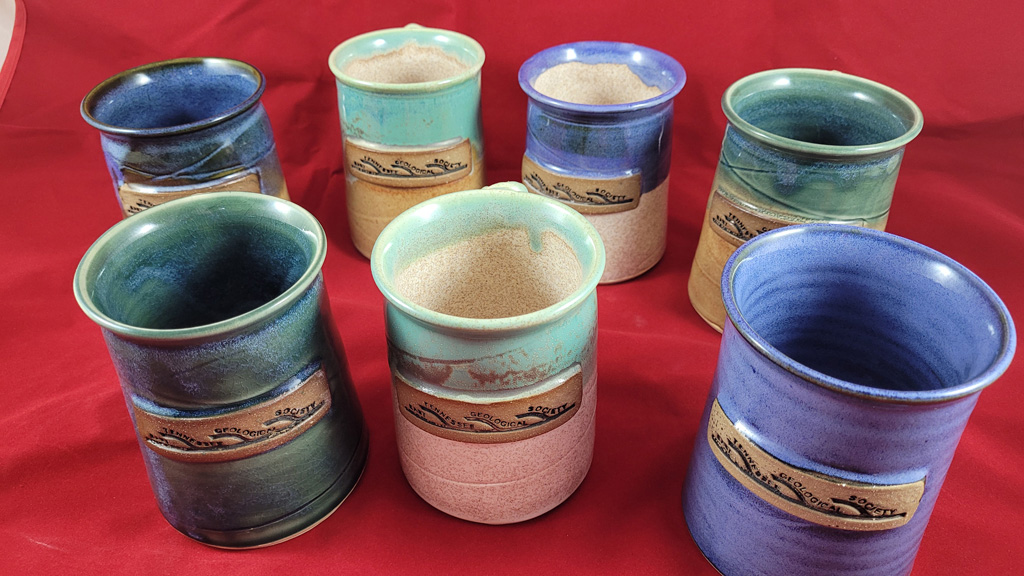
New ETGS mugs are available! If you would like to purchase a mug, email etgs@live.com and include "ETGS Mug" in the subject line.
|
|
ETGS Coffee & Beer Mugs... |
![]() |
We look forward to seeing you at the next meeting.
ETGS is a volunteer organization. We need your help to
continue serving those interested in the geology of East
Tennessee and beyond. Please email us at
etgs@live.com
if you would consider assisting in one of the following open
positions. It is a great opportunity to expand your personal
and professional network.
President
Tony McClain
Vice
President
David Carlone
Secretary
J.
Brad Stephenson
Treasurer
Seaira Stephenson
Webmaster/Social Media Coordinator
Bob
Gelinas
|
Page updated May 03, 2026 |