EAST TENNESSEE GEOLOGICAL SOCIETY
The links below will open a new window in
which various maps or images are displayed. Click on the image and use your
mouse wheel to zoom and click and drag to pan (or use your fingers to pinch in /
pinch out to zoom). You can also double tap to zoom in/zoom out.
The two links below provide a visual sampler from
the awesome Smithsonian National Museum of Natural History Exhibits
on Fossils and Minerals. If you are in the Washington D.C. area then
one word: GO!
Geologic Time & Events
Phanerozoic
Eon
(542.0 my
to present)
my = million years |
Cenozoic
Era
(65.5 my
to present) |
Quaternary (2.588 my to present)
- Holocene (11,700 yrs to present)
- Pleistocene (2.588 my to 11,700 yrs)
|
Neogene (23.03 to 2.588 my)
- Pliocene (5.332 to 2.588 my)
- Miocene (23.03 to 5.332 my)
|
Paleogene (65.5 to 23.03 my)
- Oligocene (33.9 to 23.03 my)
- Eocene (55.8 to 33.9 my)
- Paleocene (65.5 to 55.8 my)
|
|
Mesozoic
Era
(251.0 to
65.5 my) |
Cretaceous (145.5 to 65.5 my)
- Upper (99.6 to 65.5 my)
- Lower (145.5 to 99.6 my)
|
Jurassic (199.6 to 145.5 my)
- Upper (161.2 to 145.5 my)
- Middle (175.6 to 161.2 my)
- Lower (199.6 to 175.6 my)
|
Triassic (251.0 to 199.6 my)
- Upper (228.7 to 199.6 my)
- Middle (245.9 to 228.7 my)
- Lower (251.0 to 245.9 my)
|
|
Paleozoic
Era
(541.0 to
251.0 my) |
Permian (299.0 to 251.0 my)
- Lopingian (260.4 to 251.0 my)
- Guadalupian (270.6 to 260.4 my)
- Cisuralian (299.0 to 270.6 my)
|
Carboniferous (359.2 to 299.0 my)
- Pennsylvanian (318.1 to 299.0 my)
- Upper (307.2 to 299.0 my)
- Middle (311.7 to 307.2 my)
- Lower (318.1 to 311.7 my)
- Mississippian (359.2 to 318.1 my)
- Upper (328.3 to 318.1 my)
- Middle (345.3 to 328.3 my)
- Lower (359.2 to 345.3 my)
|
Devonian (416.0 to 359.2 my)
- Upper (385.3 to 359.2 my)
- Middle (397.5 to 385.3 my)
- Lower (416.0 to 397.5 my)
|
Silurian (443.7 to 416.0 my)
- Pridoli (418.7 to 416.0 my)
- Ludlow (422.9 to 418.7 my)
- Wenlock (428.2 to 422.9 my)
- Llandovery (443.7 to 428.2 my)
|
Ordovician (488.3 to 443.7 my)
- Upper (460.9 to 443.7 my)
- Middle (471.8 to 460.9 my)
- Lower (488.3 to 471.8 my)
|
Cambrian (541.0 to 488.3 my)
- Furongian (499 to 488.3 my)
- Series 3 (510 to 499 my)
- Series 2 (521 to 510 my)
- Terreneuvian (541.0 to 521 my)
|
|
|
Proterozoic
Eon
(2500 to 541 my) |
|
Neoproterozoic Era (1,000 to 541
my) |
Ediacaran (635.0 to 541.0 my)
|
Cryogenian (720.0 to 635.0 my)
|
Tonian (1000 to 720.0 my)
|
|
Mesoproterozoic Era (1,600 to 1,000
my) |
Stenian (1200 to 1000 my)
|
Ectasian (1400 - 1200 my)
|
Calymmian (1600 - 1400 my)
|
|
Paleoproterozoic Era (2,500 to 1,600
my) |
Statherian (1800 - 1600 my)
|
Orosirian (2050 - 1800 my)
|
Rhyacian (2300 - 2050 my)
|
Siderian (2500 - 2300 my)
|
|
|
Archean
Eon
(4000 to 2500 my) |
|
Neoarchean Era (2,800 to 2,500 my) |
-
|
|
Mesoarchean Era (3,200 to 2,800 my) |
-
|
|
Paleoarchean Era (3,600 to 3,200 my) |
-
|
|
Eo Era (4,000 to 3,600 my) |
-
|
|
Hadean
Eon
(4600 to 4000 my) |
|

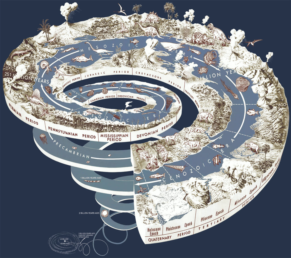
Credit:
By United States Geological Survey - Graham, Joseph, Newman,
William, and Stacy, John, 2008, The geologic time spiral—A path to
the past (ver. 1.1)
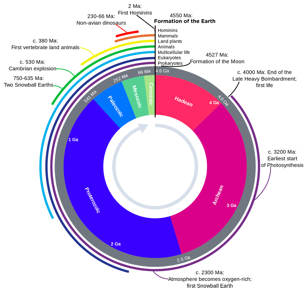
Credit: By
WoudloperDerivative work: Hardwigg
| |
Page updated
October 01, 2023
|